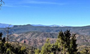
This Appalachian Trail summit provides some of the best views in the southeast.
Near: Hot Springs, NC
Distance: 9.5 miles round trip
Elevation Gain: 2422 ft
Hike Time: 5.5 hours
Difficulty: Moderate
Trail Condition: Well maintained trail
Hike Type: Out and Back
There are many variations to enjoy Max Patch. My favorite is to hike from the lower loop of Max Patch to Lemon Gap and resting at the Roaring Fork Shelter for lunch.

Alternatively, you could drive about 5 miles further past Max Patch parking area to reach Lemon Gap parking and start there and hike to Max Patch eat lunch on top of the world and hike back or to share just the views with those of ages 7 to 70 you could just hike the 1-mile loop trail.
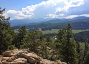
If you would like to introduce someone to hiking, the trek from Max Patch to Lemon Gap would be great. Except for the dramatic approach to Max Patch this section of the AT is mainly rolling soft hills that a novice hiker would not realize the 10 miles or so you would log at the end of the day. Once you reach the summit of Max Patch (hopefully a clear day) the 360-degree views will simply overwhelm you! Bring your camera. You’ll be glad you did.
Trailhead
From Knoxville: I-40 East to Exit 7 Harmon Den (NC). Turn left at end of exit ramp onto the gravel road. Follow this road for about 6 miles then turn left until it ends. Turn left onto Max Patch Road, the parking area is about 2.5 miles on right.
There is a loop trail of 1 mile just for Max Patch but to reach Lemon Gap use the left side of the loop and it will connect to the AT. Head Northeast on the AT for 4 miles to reach Lemon Gap or just short at Roaring Fork Shelter.
(Lat:35.79657 Lon:-82.96273)